Due to glacier erosion on Mount Rainier, its' physical appearance and shape continues to be altered. The following picture illustrates a map of all of Mount Rainier's glaciers.
Glacier erosion has caused scarring and furrowing spanning from the cone to the base. As discussed in an earlier post, large pieces of the volcano’s cone were launched miles
away and no can be seen “on the mountain flanks as sharp crags and ridges (the
“cleavers”) that jut through the ice and separate the radiating glaciers
descending from the snowy summit. (Harris, Tuttle, and Tuttle 516)” Glacier ice
continues to erode the new cone that has develop. This can be seen in the image below that illustrates an example of glacier ice eroding a piece of displaced rock that resulted from the violent explosion.
 |
| Map of Mount Rainier's major glaciers (Walder, and Driedger) |
 |
| Picture taken by Tim Martin of Gibraltar Rock which is being eroded by the Ingraham glacier (Martin) |
Tunnels and steam caves lie under these hundreds
of feet of snow filling the small craters, it is even possible for lakes to
form on top of these craters. The picture below is an example of an ice cave that formed in 1982.
 |
| Paradise Ice caves at Mt. Rainier, melted away in 1991 due to the Nisqually drawing back.Photo credit: Gilbert W. Arias/Seattle Post-Intelligencer/ SL (Arias) |
Avalanches are common due to the immense amounts
of annual snowfall. It is believed that “26 named glaciers, occupying around 50
square miles of land surface, are in Mount Rainier National Park. (Harris,
Tuttle, and Tuttle 518)” The following picture is an example of an avalanche that resulted due to the displacement of a large piece of glacier.
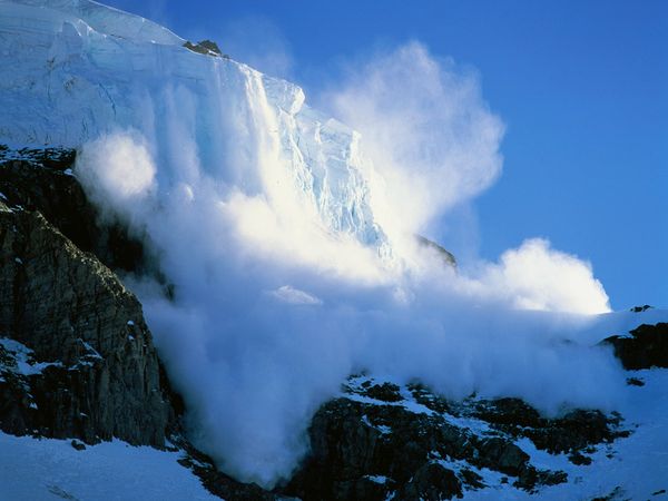 |
| Avalanche on Mount Rainier caused by the displacement of a large piece of glacier (Muench) |
The most apparent form of glacier
erosion can be seen in the headwalls such as the Willis Wall. Willis Wall was
opened up and expanded due to glacier erosion, it is said “the cirque stores
the snow and ice that enables the Carbon Glacier to descend to an altitude
lower than any other glacier on the mountain. (Harris, Tuttle, and Tuttle 518)” You can see a picture of Willis Wall below which is recording having a headwall of "3600 feet and a diameter of a mile and a half (Harris, Tuttle, and Tuttle 518). "
 |
| Willis Wall largest cirque on Mount Rainier (Swayne) |
Information and pictures from this post are credited to the following sources:
Harris, Ann G., Esther Tuttle, and Sherwood D. Tuttle.Geology of National Parks. sixth ed. . Dubuque,Iowa: Kendall/Hunt Publishing Company, 2004. 516-518. Print.
Martin, Tim. "Gibraltar Rock, Mount Rainier." EPOD. NASA's Earth Science Division, 01 Mar 2002. Web. 18 Feb 2012. <http://epod.usra.edu/blog/2002/03/gibraltar-rock-mount-rainier.html>.
Walder, Joseph, and Carolyn Driedger. "Glacier-Generated Debris Flows at Mount Rainier." USGS. CVO, 11/22/02. Web. 18 Feb 2012. < >.
Arias, Gilbert W.. "Our Warming World: Effects of climate change bode ill for Northwest." Seattle P.I.. Hearst Communications Inc, 12 Nov 2003. Web. 19 Feb 2012.
Muench, Marc. "Avalanche Safety Tips." National Geographic . National Geographic Society, 2012`. Web. 19 Feb 2012.
Swayne, Michael D.. "The Serious Sixties." Northwest Mountaineering Journal. Northwest Mountaineering Journal, 2007. Web. 19 Feb
No comments:
Post a Comment