Sunday, February 19, 2012

Mass Wasting


Due to the fire and ice effect taking place in Mount Rainier National Park, and the immense eroding of the glaciers, mass wasting is extremely prominent. According to the textbook, “the interaction of processes of mass wasting, weathering, volcanism, and glaciation has created a powerful group of mechanisms for eroding, transporting, and depositing debris far and wide” (Harris, Tuttle, and Tuttle 519).  This raises a great deal of concerns and questions regarding not only the safety of the environment surrounding and in Mount Rainier National Park, but also the surrounding life.  
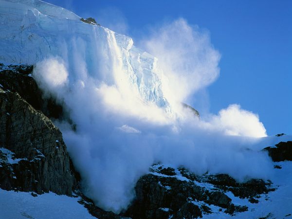
Because Mount Rainier is fire and ice, volcano-watchers not only have to keep watch for lava flows and ash fall, they also have to keep water for avalanches and immense snow fall. Unlike most mountains, because Mount Rainier is affected by both fire and ice, it is not uncommon for watchers to see both of these occurring in the same exact day. Because of this, it is that much more important to monitor Mount Rainier because there are so many things that can come into play that can drastically effect the surrounding environment.  Many of these violent changes can happen with in succession of each other, whether it is intense mudflows destroying all vegetation and life that stands in its’ way all due to heavy rainfall, or avalanches and rock falls that result from stream explosions(Harris, Tuttle, and Tuttle 519-521). The following is a map of mudflows and deposits from Holocene Time.
Map of Mudflows, lava flows and deposits during Holocene Time
(Harris, Tuttle, and Tuttle 521)

 All of these things have the very potential to destroy the local environment in and around Mount Rainier National Park.  This is especially important because it is recorded that “ lahars and mudflows travel at speeds of about 50 miles per hours” (Harris, Tuttle, and Tuttle 521). Because of this Mount Rainier National Park is constantly checking the conditions of Mount Rainier in both fire and ice aspects, and has set up not only an effective warning system but also evacuation plans for surrounding areas. This is because with mudflows and lahars moving at such speeds, and the potential for lava flows to be moving even faster, it is important that Mount Rainier National Park is able to effectively and efficiently warn all locals and visitors early enough for them to be able to clear the area before these mudflows, lahars or lava flows reach them. (Harris, Tuttle, and Tuttle 519-521)


Information and pictures from this post are credited to the following sources:

Harris, Ann G., Esther Tuttle, and Sherwood D. Tuttle.Geology of National Parks. sixth ed. . Dubuque,Iowa: Kendall/Hunt Publishing Company, 2004. 519-21. Print.

Glaciers


Glaciers are one of the main sources for streams and hydroelectric power for many surrounding areas, this is why it is extremely important to constantly monitor Mount Rainier’s glaciers and how rapidly they are melting and shrinking. Depending on the location of the supplying glacier and the temperature, the streams can be anywhere from rapid or easily crossed on foot. It is also common to see streams that are a white, milky color; this color is attributed to grains of rock flour that has beencreated from the moving glaciers. The picture below shows the milky-white river water color of the North Fork Nooksack River, whose color was caused by the melting and moving glaciers. (Harris, Tuttle, and Tuttle 518)
 
North Fork Nooksack River
(McShane)
Melting glaciers can also be seen forming ice caves, waterfalls tributary streams and lakes. The following pictures are examples of ice caves and waterfalls that can be seen at Mount Rainier National Park. 
Waterfall created from glaciers at Mount Rainier National Park
(Augustin)

Paradise Glacier Ice Cave
(Harris, Tuttle, and Tuttle 520)

Mount Rainier is home to many Valley Trains, which are “made up of outwash deposited by meltwater streams, cover the floors of the narrow valley that descend from the ends of the glaciers” (Harris, Tuttle, and Tuttle 518). You can see many of these valley trains on Mount Rainier, however they are constantly changing due to the mountains mudflows and ash falls. The following images is an example of a valley train and stream that lies below the Nisqually River on Mount Rainier. 
Valley Train and stream below Nisqually River
(Sherman)

Information and pictures from this post are credited to the following sources:

Harris, Ann G., Esther Tuttle, and Sherwood D. Tuttle.Geology of National Parks. sixth ed. . Dubuque,Iowa: Kendall/Hunt Publishing Company, 2004. 518-20. Print.

McShane, Dan. "Glacial Milk in Western Washington Rivers." Washington Landscape. blogspot.com, 14 Aug 2011. Web. 19 Feb 2012. 


Sherman, Doug. "Alpine Glaciation." PBase. PBase LLC, n.d. Web. 19 Feb 2012. <http://www.pbase.com/dougsherman/image/93200947>.


Augustin, Haley. "Mount Rainier Waterfall HDR."AugustinH. deviantART, 01 Aug 2010. Web. 19 Feb 2012. <http://augustinh.deviantart.com/art/Mount-Rainier-Waterfall-HDR-173548394>.


Saturday, February 18, 2012

The Erosion Effect


Due to glacier erosion on Mount Rainier, its' physical appearance and shape continues to be altered.  The following picture illustrates a map of all of Mount Rainier's glaciers. 


Map of Mount Rainier's major glaciers
(Walder, and Driedger)
Glacier erosion has caused scarring and furrowing spanning from the cone to the base.  As discussed in an earlier post, large pieces of  the volcano’s cone were launched miles away and no can be seen “on the mountain flanks as sharp crags and ridges (the “cleavers”) that jut through the ice and separate the radiating glaciers descending from the snowy summit. (Harris, Tuttle, and Tuttle 516)” Glacier ice continues to erode the new cone that has develop. This can be seen in the image below that illustrates an example of glacier ice eroding a piece of displaced rock that resulted from the violent explosion.


Picture taken by Tim Martin of Gibraltar Rock which is being eroded by the Ingraham glacier
(Martin)


Tunnels and steam caves lie under these hundreds of feet of snow filling the small craters, it is even possible for lakes to form on top of these craters. The picture below is an example of an ice cave that formed in 1982.

Paradise Ice caves at Mt. Rainier, melted away in 1991 due to the Nisqually drawing back.Photo credit: Gilbert W. Arias/Seattle Post-Intelligencer/ SL   (Arias)


Avalanches are common due to the immense amounts of annual snowfall. It is believed that “26 named glaciers, occupying around 50 square miles of land surface, are in Mount Rainier National Park. (Harris, Tuttle, and Tuttle 518)”  The following picture is an example of an avalanche that resulted due to the displacement of a large piece of glacier. 
Avalanche on Mount Rainier caused by the displacement of a large piece of glacier
(Muench)
The most apparent form of glacier erosion can be seen in the headwalls such as the Willis Wall. Willis Wall was opened up and expanded due to glacier erosion, it is said “the cirque stores the snow and ice that enables the Carbon Glacier to descend to an altitude lower than any other glacier on the mountain. (Harris, Tuttle, and Tuttle 518)” You can see a picture of Willis Wall below which is recording having a headwall of  "3600 feet and a diameter of a mile and a half (Harris, Tuttle, and Tuttle 518). " 
Willis Wall largest cirque on Mount Rainier
(Swayne)

Information and pictures from this post are credited to the following sources:

Harris, Ann G., Esther Tuttle, and Sherwood D. Tuttle.Geology of National Parks. sixth ed. . Dubuque,Iowa: Kendall/Hunt Publishing Company, 2004. 516-518. Print.


Martin, Tim. "Gibraltar Rock, Mount Rainier." EPOD. NASA's Earth Science Division, 01 Mar 2002. Web. 18 Feb 2012. <http://epod.usra.edu/blog/2002/03/gibraltar-rock-mount-rainier.html>.


Walder, Joseph, and Carolyn Driedger. "Glacier-Generated Debris Flows at Mount Rainier." USGS. CVO, 11/22/02. Web. 18 Feb 2012. < >.


Arias, Gilbert W.. "Our Warming World: Effects of climate change bode ill for Northwest." Seattle P.I.. Hearst Communications Inc, 12 Nov 2003. Web. 19 Feb 2012. 


Muench, Marc. "Avalanche Safety Tips." National Geographic . National Geographic Society, 2012`. Web. 19 Feb 2012. 


Swayne, Michael D.. "The Serious Sixties." Northwest Mountaineering Journal. Northwest Mountaineering Journal, 2007. Web. 19 Feb 

Friday, February 17, 2012

Geological Features of Mt. Rainier


Mount Rainier geological make up is both that of fire and ice, which is a combination of both volcanism and glaciation. Being affected by both fire and ice has drastically contributed to the volcanoes transformation in appearance since its existence. Approximately 5700 years about the summit of Mount Rainier was destroyed due to a violent explosion that resulted in large pieces of both glacier and rock being launched miles away. This explosion caused mudflows to burn down the valleys. This violent explosion created caldera, which occurs after a violent volcanic explosion and results in a large basin.  After all the commotion of the explosion was over it wasn’t long before the glaciers were able to rebuild themselves. The rebuilt glaciers once again began the erosion process, yet it wasn’t until thousands of years later that the summit was rebuilt due to ash falls and lava flows. Although a new cone could be created, lava continues to over then cone and create vents. The map below shows a map of these lava flows and the glaciers that make up Mount Rainier. 
Map of Mount Rainier Lava flows and Glaciers
(Decker, and Decker)


Even though Mount Rainier remains to be an active volcano, an extraordinarily large portion of its’ eruptions are attributed to lava flows and only 10% of its’ eruptions being pyroclastics. (Harris, Tuttle, and Tuttle 513-514)

Information and pictures from this post are credited to the following sources:

Harris, Ann G., Esther Tuttle, and Sherwood D. Tuttle.Geology of National Parks. sixth ed. . Dubuque,Iowa: Kendall/Hunt Publishing Company, 2004. 513-514. Print.

Decker, Robert, and Barbara Decker. "Dartmouth." Road Guide to Mount Rainier National Park. Double Decker Press, 1996. Web. 18 Feb 2012. <http://www.dartmouth.edu/~volcano/texts/DekRainier.html>.

Mt. Rainier Overview


Mount Rainier is the highest mountain in the Cascade Range, standing at over 6000 feet from the base of the Columbia Crest . The picture below shows the Columbia Crest and the other glaciers and remnants of the cone after the explosion.

Geographic locations of Mt. Rainier's Glaciers and remnants of volcanic cone that were destroyed after explosive eruption.
(Harris, Tuttle, and Tuttle 511)


 Mount Rainier is what is called a composite volcano, which is a "steep volcanic cone built by both lava flows and pyroclastic eruptions (Woods). " Due to eruptions in Holocene time, the volcanic cone and summit crater have been destroyed; the picture below illustrates the approximate maximum size of Mount Rainier. 
The approximate maximum height that Mt. Rainier would stand if not for  eruption in Holocene time.
(Harris, Tuttle, and Tuttle 514) 


These eruptions and lahars are not only in the past but have the potential and likelihood to occur again in the future. With Mt. Rainier, and active volcano just about 60 miles outside of Seattle, Washington, this poses high risk for surrounding areasWith this in mind, Mount Rainier National Park has volcano watchers that regularly monitor Mount Rainier on a daily basis. These volcano watchers are on the look for things like lava flows, ash falls, along with heavy rain or heavy snowfall that may cause avalanches or mudflows. It is extremely important that Mount Rainier National Park monitors the volcano for all of these things, in order to be fully prepared for any changes in activity and conditions that may dramatically effect the surrounding environment and life. (Harris, Tuttle, and Tuttle 511-513).

Information and pictures from this post are credited to the following sources:

Harris, Ann G., Esther Tuttle, and Sherwood D. Tuttle.Geology of National Parks. sixth ed. . Dubuque,Iowa: Kendall/Hunt Publishing Company, 2004. 511-513. Print.


Wood, Dr. Chuck. "Definitions." Volcano World. Oregon Space Grant Consortium, 2011. Web. 17 Feb. 2012 <http://volcano.oregonstate.edu/glossary/1/letterc>.